

12:00 AM Tue 20 October 2026
Jose Borrero figures he has the best job in the world . . . and it just so happens it’s one that could potentially save the lives of many.
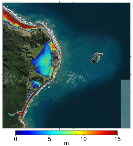
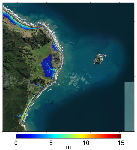
The Tairāwhiti-based coastal scientist and engineer has just completed mapping the entire area using the very latest topography (high resolution imagery of the land) and bathymetry (topography from under the water) available. That in turn creates a line to let people know how far they need to evacuate to should there be a tsunami warning.
“Using these two I can make a really accurate representation of the shape of the coastline which improves the predictions of potentially inundated areas in an extreme tsunami event,” he says.
The work was commissioned by Tairāwhiti Emergency Management (TEMO). Group manager Ben Green says the extended LiDAR coverage was timely for the region. LiDAR (Light Detection and Ranging) is a mapping technique using a laser to measure the height of terrain.
“We initially commissioned the work to complete the tsunami zones given there were data gaps in the maps, however now that the LiDAR coverage has been completed we can update that to include the entire coastline,” said Mr Green.
The maps will be accessible on the TEMO website once ORCAS has completed the modelling.
“Our region has a tsunami risk and awareness campaigns like ShakeOut really seek to connect with whanau so they can have a sense of safe zones and having a plan.”
He encouraged everyone to be part of the ShakeOut campaign on Wednesday.
The original mapping of Tairāwhiti was done by Mr Borrero in 2018 but the new mapping means everywhere from the beach at the mouth of the Maraetaha River, south of Te Kurī a Pāoa (Young Nick’s Head), north to Lottin Point at the top of the Coast is now fully covered.
“It is great to have clear definition of where the flow paths are and it showed us that some communities may not be as vulnerable as previously thought,” said Mr Borrero.
Other areas are not so lucky and may need to re-think their evacuation routes. Mr Borrero is happy to meet with coastal communities to further explain the new modelling. “I love helping people understand the hazard. It is important to remember that what we are producing is the most extreme scenario – it is extremely unlikely, but we have to define the worst case as a start. In any event, when you feel the earthquake you don’t know if you are far away from a big event or close to a smaller one. They could both feel the same, so it is very important to know your evacuation routes.”
The extreme scenarios use tsunami sources analogous to the 2011 Japan tsunami positioned offshore of Tairāwhiti. “We have a similar type of faulting offshore that Japan has, so even though geological and historical records don’t show evidence of a tsunami that big, you cannot discount the possibility of a huge earthquake happening.”
Both nations are situated along subduction zones, the interface between two tectonic plates known to produce the earth’s biggest earthquakes and tsunamis.
One of the challenges Mr Borrero faced while doing the new mapping was whittling down a huge amount of information to make it manageable but still accurate.
“If you visualise a fish net with one metre spacing laid across the earth, and at each point where the lines cross is one piece of data – that’s a lot to deal with!” he said.
Mr Borrero is a co-director of ORCAS Consulting, a company that focuses on coastal hazards, climate change adaptation, surf science and tsunamis.
“I am a coastal person, and I like looking at all the nooks and crannies of the coastline and thinking about the different surf spots that may or may not be there . . . I daydream about driving up the coast to check them out.”
ShakeOut 2026 is on Wednesday (October 21) at 1.30pm.